Track Plans With a Little Virtual Help

I recently completed most of the remaining track work on the Old Main at the north end of Circleville. All of the industries along that stretch have their track, turnouts, and associated wiring in place, excepting Container Corporation’s shipping and receiving yards. Most recently, I added all of the turnout controls, making the north end fully operational. More on those details in another post.

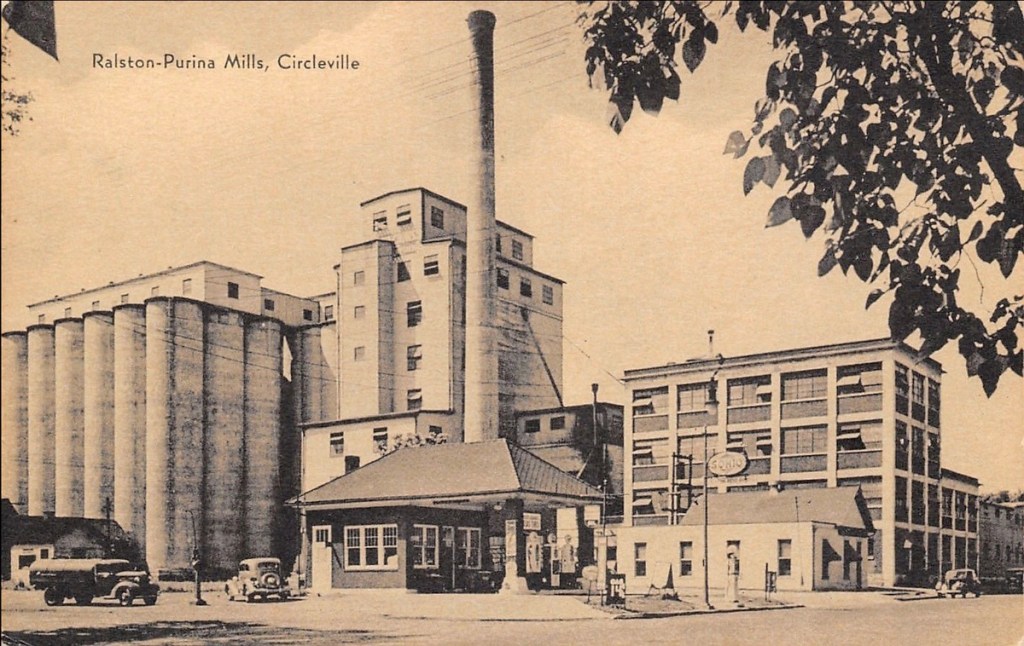
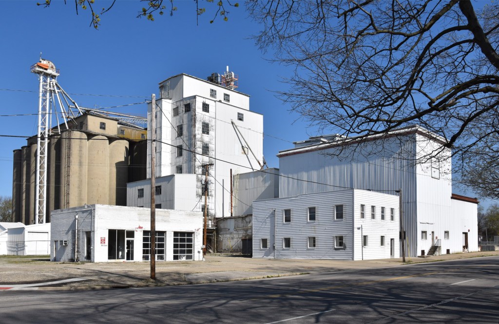
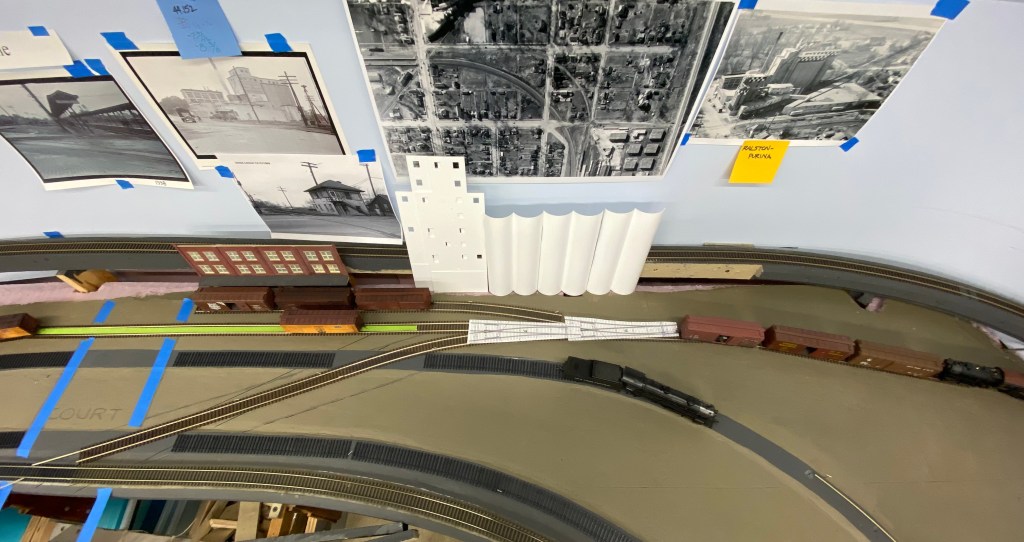
That milestone got me thinking about extending the track work further to the east, along Huston Street. The major industry here was Purina Mills, which I wrote about in a previous post. The trackage around the area is relatively complex due to the nearby interchange between the N&W and the Pennsylvania Railroad. Reproducing that in model form is going to be difficult due to the prototype’s track layout and the relatively confined space I have to squeeze the reproduction into.

I kicked around some ideas, but decided I needed feedback from people who regularly operate model railroads – folks that could tell me whether my proposed plan would work or not. The problem was, how do you do that when having visitors in the layout room is difficult?

The solution was to use what everyone has become familiar with in the past nine months – video conferencing. Several modelers with operations experience volunteered to help, so it was up to me to work out a way to present the prototype and model situations in a way that made sense on a video screen.

Here’s what I came up with:

  • Zoom Video Conference application
  • Google Maps
  • Three cameras;
    • iPhone 11 (my current phone)
    • iPhone 7 (my previous phone) with a Joby Gorillapod tripod
    • An iPad
  • Laptop to manage the call and which camera views were visible.

Setup

I suspended the iPhone 7 above the layout using the Gorilla-pod. This was the first time I’ve tried using this tripod in a hanging position, and it worked really well. The iPad setup was simpler; I propped it up at track level, on the opposite side of the scene from the iPhone.

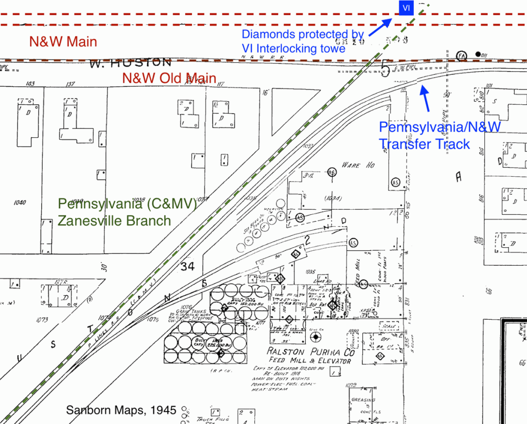
Before the call, I built a Google Map (learn how here) to show the actual track layout in Circleville in order to provide context. In the screenshot below, the N&W is indicated with red lines and the PRR with green. The fatter/brighter lines indicate where the model’s track would have to deviate from the prototype to avoid the basement wall.

Presentation

I started the call by sharing my desktop with the Google Map displayed. I described the railroad’s route Circleville, followed by zooming into the specific area I needed help with – the Purina Mills complex. The reason for showing the entire map initially was to give the viewers a better sense of how trains would approach the area in question.

Following the map overview, I stopped the screen share and went to the video displays – the ground-level iPad, the aerial iPhone 7 and the iPhone 11. The latter I used temporarily to walk around the basement in order to connect the map overview with what I had built in model form, and how it led into the area I needed help with.

Making more than one video feed usable requires using a more advanced feature in Zoom called “Spotlight”. By default, Zoom will show the video of the person speaking (or their name if their camera is turned off). This is fine for a normal conversation, but isn’t helpful when everyone needs to talk and see a particular video feed!

To solve this, the host adds one (or more) videos to a list of spotlighted views, which keeps those views on everyone’s screens, even during back and forth conversation.

The image below shows what everyone saw during the discussion. For a short time, I had the third, walk around, camera on the screen as well. I turned that camera’s video off as soon as the walk around was complete to keep things simple.

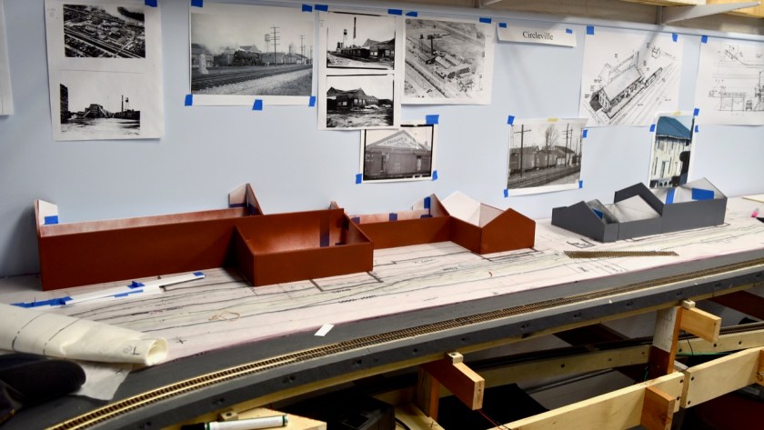
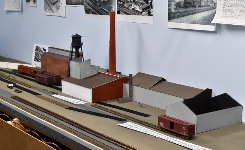
The final track arrangement for Purina Mill and the N&W/PRR Transfer Track is pictured below. The major differences, compared to the prototype arrangement are:

  • Purina Mill will have one warehouse track instead of the prototype’s two. In the photo, the warehouse track is next to the brick building, with three boxcars
  • There is no second track (running track) parallel to the PRR main. Compare to the Google map screenshot above.
  • The warehouse and transfer track (marked with green tape) will both connect directly to the PRR main, instead of a separate running track
  • The transfer track is straight and the PRR main is curved, the opposite of the prototype

My goals were to retain the general feel of the area and reproduce the three diamonds created by the crossing of the PRR over the N&W’s double track main line, and single track Old Main industrial track. My concern was whether those two goals would impact operability – my main concern was the relatively short PRR main to the right of Purina, which would have to serve as a tail track to switch the industry.

The general agreement was that it was long enough (three 40′ cars and a locomotive), and was right-sized for the transfer track (three cars) and warehouse track (also three cars). The end of the track is a long reach, but the coupling area is within reasonable reach.

Closing

Overall, the virtual brainstorming was successful, from my point of view. I got some good feedback on my track arrangement and had a chance to test video-conferencing in a “hands on demonstration” capacity. I am the Superintendent of my local NMRA Division, and wanted to test this use case before suggesting it to the members in my Division for similar training and/or educational purposes.

There are a couple of caveats to doing this. I was using a “Pro” account which allows longer calls with multiple members. You could also do this with a free account, but the call would be limited to 40 minutes – and the “Spotlight” feature may not be available. It also is worth mentioning that this entire presentation could have been accomplished with one camera – it just would have been a more limited view.

Thanks for reading my blog. If you have any questions or additions, please share a comment in the section below. If you know others that might be interested in this blog, feel free to share the link.

Ralston-Purina Visit

Recently my wife and I made the forty-minute drive to Circleville to take some photos of the former Ralston-Purina plant. Of the industries and buildings I will be including on my model railroad, this is the only one that still (largely) exists from the timeframe I am modeling.

That visit got me thinking, and I broke out my collection of photos, articles and maps to see how things fit together. In this post, I’ll compare photos from today to “back in the day”, provide a little plant history that I’ve scraped together, and go over a bit of rail operations. I’ll also touch on how I intend to model the structure.

Then vs. Now

It’s remarkable how little has changed over the decades. Ben Shahn took the following photo in 1938, as part of his work with the FSA (Farm Security Administration). This is my go-to reference for this building due to its detail and timeframe.

Mr. Shahn took many photos of the Circleville area, and his collection, housed in the Library of Congress, is one reason I chose my particular modeling year. The photos are great references for buildings of course, but also for period environmental details. This particular photo includes bicycle riders, a mix of brick and asphalt street paving, trucks, weedy side tracks, coal hoppers, train order semaphores, etc. Great stuff.

Comparing the previous photo to mine from 2020 shows little change, other than the missing warehouse (where the truck dock is in the 1938 photo), soybean oil tanks, and chimney, and some added sheathing.

Similarly, the southeast side of the plant also show few changes. The first photo below is a postcard, circa 1940; the second is my photo from 2020. Both are both taken from roughly the same spot. The biggest changes are the addition of siding and the subtraction of the boiler’s chimney.

A Brief History of the Mill

Part of the fun of building models of specific buildings or places is the research that goes along with it. The most helpful for this facility were old editions of the Circleville Herald (via Newspapers.com) and Sanborn Fire Insurance maps. The Pickaway County Historical and Genealogical Library has also been a huge help.

On the 1927 Sanborn fire insurance map, the property was referred to as “H.M. Crites & Co. Flour Mill & Elevator”, was “re-built” in 1918 and had a 100,000-bushel capacity. According to a 1933 Herald article, Mr. Crites acquired the property in 1918 and presumably was responsible for the rebuilding. It’s not clear how extensive the rebuilding was, but it appears that the concrete headhouse and brick/concrete office were added, possibly replacing an older wooden structure.

At some point, the mill was sold to the Dixie Mills Company, whose properties (this and several others) were sold at auction at the courthouse in January of 1925, apparently to Mr. Crites. I suspect that the Dixie Mills Company was controlled by Mr. Crites, and that he bought it from himself at that auction.

In any case, Mr. Crites was back in control of the mill by 1933. In that year, he sold the property to Ralston-Purina in a transaction involving eight (or ten, depending on the source) additional properties. In reporting on the transaction, The Herald stated that Mr. Crites had “vast agricultural holdings … throughout several central Ohio counties” and “Mr. Crites pointed out [the S. Court st plant] is valued at $350,000” and all nine (or eleven) had a value just under a half-million dollars. Quite a sum in 1933. The deal was described as “one of the biggest in Pickaway-co’s history“.

Ralston-Purina immediately began refitting the property, converting it from a flour mill to a feed mill. They installed two French soybean oil expellers in January, 1935, and four more the following summer. These gave the plant the capacity to process up to one million bushels of beans per year.

Those expellers needed beans, so the company also made a pitch to local farmers to start planting them, as described in a 1934 advertisement in The Herald (left). They also planned to provide seed starting the following year.

The photo accompanying the advertisement nicely illustrates the physical arrangement of the time. The storage bins that are landmarks today did not yet exist.

In 1936, new slip-form concrete “tanks” were constructed, with a capacity of 200,000 bushels. This first set are along the tracks, directly west of the head house. In 1939, an additional twelve tanks were added to the immediate southwest of the first set. These added another 250,000 bushels.

Also in 1939, the company removed an old brick building that sat along Court Street (on the north side of the brick office building) and built a new metal-clad, two-story warehouse to store feed produced in the plant. To the rear (west) of this new building, a three-story metal-clad building to house equipment for manufacturing livestock and poultry feed was added. Some of these improvements are visible in the Ben Shahn photo.

And that brings us up to date for my modeling period!

Railroad Service

In 1938, the plant was served directly by the Pennsylvania Railroad’s Zanesville branch, which ran from Zanesville to Morrow. The branch was often referred to as the C&MV (Cincinnati and Muskingum Valley) after the company that built the line in the 1850s. The plant was also served indirectly by the N&W (Norfolk and Western), via an interchange/transfer track from Huston St.

Pennsylania’s Zanesville branch connected Zanesville and Cincinnati, via Morrow, Ohio. Circleville was one of the heaviest shipping points between Zanesville and Morrow. 1927 Sanborn Fire Insurance Map with 1945 updates. Annotations by Matt Goodman

Purina was a money-maker for the Pennsylvania railroad. It, along with the Eshelman Feed Mill a quarter mile to the east, made Circleville the heaviest shipping point along the entire branch. In later years, the branch was stubbed at the Scioto River when the bridge over the river was determined to be unsafe for the traffic of the day.

From an operations perspective, I’ve found evidence of a surprisingly wide variety of car-types being delivered to the plant.

  • Boxcars for delivering soybeans and other ingredients used in feed products
  • Boxcars for shipping the final product
  • Hopper cars to deliver coal for plant power and steam heat
  • Tank cars to deliver petroleum products for the neighboring filling station/garage.

The area around the Ralston-Purina plant was cramped, from a railroad switching perspective. The mill, a busy US Highway crossing (S. Court Street/U.S. 23), two interlocked Norfolk and Western crossings, and the N&W interchange track were right on top of one another at the east end. The upside was that all of the switching could be done from the west end, which had only one side street crossing (Harrison Street – just out of view in the map above).

It appears that none of the tracks in the Purina area were double-ended, so the crews couldn’t do a traditional run-around move to get the locomotive onto the east end of a train after switching was complete. However, railroaders from the 1980’s have told me that they got around this problem by using a “gravity drop” with the aid of a light descending grade toward the Scioto River. The crew would move the locomotive out of the way, then release the brakes on the cars they wanted to remove. The cars would drift west past the locomotive, which could then couple to the east end of the cars. It seems reasonable to assume that the same moves would have been done in 1938-9.

Modeling

I’d always planned on representing the plant on the model railroad, given its visual and economic prominence in this part of Circleville. Initially, it’s inclusion was only going to be cosmetic, but after learning all that I’ve typed above (and finding I had more space on the model railroad than I thought), I am now motivated to include Purina as an active switching point. Those operating plans, however, are in the future.

The plans for modeling the building itself consist of a pretty straight forward kitbash. The base for the model will be Walther’s ADM Grain Elevator kit, which represents a slip-form concrete storage facility. This model has the same relatively compact profile as Purina.

Walther’s Cornerstone model of a slip-form elevator.

Although a good starting point, the kit is too short vertically and horizontally. The prototype structure is relatively compact in the grand scheme of things (great for a model railroad!), but it’s much bigger than a railroad car – refer again to the Ben Shahn photo. My modeling philosophy is to preserve these proportions where possible.

To get there, Christy and I will bash two of the kits together to give it more visual “heft”. The changes will involve the following:

  • Raise the kit’s head house “shoulders” from 76 to 90 scale feet and it’s “head” to 100 feet
  • Raise the height of the kit’s storage bins from 63 to about 80 scale feet
  • Add four more storage bins (twelve vs. the model’s eight) to increase the horizontal footprint

That build will be the subject of some future post.

Thanks for reading my blog. If you have any questions or additions, please share a comment in the section below. If you know others that might be interested in this blog, feel free to share the link.

Container Corporation Site Arrangement

Container Corporation, ca late forties

Container Corporation’s strawboard mill was the largest industry in the section of Circleville I’m modeling in 1938, and will also be the busiest industry on my model railroad. Since deciding that Circleville would be a focus of the railroad, I’ve gone through many design ideas for the mill’s site, structure, and track layout to best suit my goals.

Plant Siting

One thing that was never in doubt was the location of the plant on my model railroad. In the real world, the mill was located alongside the N&W Railroad and Canal Street at a point where the railroad makes a ninety-degree bend. This curve made a room corner the logical location to model this part of the railroad, which in turn made the same corner the ideal location for this plant.

So the general siting of the plant was easy. Sizing it turned out to be more difficult, with each attempt teaching me something that led to another attempt. In the end, the effort made me happier with the result.

Arrangement 1

When I first designed the layout using CAD, the Container Corporation’s footprint – in fact, all of Circleville – was relatively compact. The plant was tucked close to the room corner, with the remainder of Circleville’s industries extending down the wall to the right (north). As I learned more about the plant, I gradually stretched it’s footprint and moved it further from the corner. However, these changes were limited by the other industries in this stretch – the space available was finite.

After the benchwork was built, dad and I laid out the entire industrial stretch on tracing paper – this is dad’s preferred technique, adapted from his day job. Each industry was sized to fit the space, in proportion to one another.

Following the pencil-and-pen planning, I set about building a mockup of the plant. This raised the question of compression. I ultimately decided to size the whole plant using the coal shed/boiler room as the point of reference. The prototype shed was about 105 feet – or about long enough to house three coal hoppers. I shortened it to two hopper-lengths and applied the resulting 60-65% compression to the rest of the plant buildings.

Even with this compression, the full plant was bigger than I expected. It’s one thing to see a two-dimensional footprint, another to have a physical object as a hard reference. This more-imposing-than-expected building forced the rest of Circleville a bit north.

With the mock-up in place, I also realized that the close-to-the-corner siting would make it difficult to get track into the receiving yard without concessions in curve radius, track length and turnout locations. It would also have scenic impacts as it would leave no room for contextual buildings – specifically straw ricks and a small residential area on the south (left) end of the plant.

Over a couple of months, I started moving the plant to the right to address those concerns, which compressed the rest of the industries like a slinky.

Arrangement 2 and 3

After fussing with the compressed industrial stretch for several months, I decided to do a more comprehensive re-think of the entire Circleville industrial stretch, from Ohio Street (in the left corner) to Hargus Creek (right), in order to loosen things up.

After considering what was important to me – namely, operationally interesting or personally relevant structures – I decided to remove an entire block between Main Street and Hargus Creek on the right end. There were no rail-served industries at that end so there was no downside, other than the loss of a cool canal-era building. The upside was gaining an additional 31″ that the rest of Circleville could “grow” into. All of the industries gained more elbow room; CCA (at the opposite end) got a good chunk of that newfound space.

The additional breathing room more-or-less addressed the left-end track work concerns. There was now reasonable room to get trains in and out of the plant’s receiving yard. Details on that layout will be in a future post.

Plant Revision

During this same timeframe, I decided to revise the plant mock-up. The first mock-up was based on 1920’s dimensions and aerial photo, which I thought would be appropriate for my 1938-39 modeling time frame. Additional research unearthed information and photos showing that assumption was incorrect. The entire left end of the plant changed in 1936-1937.

I’d been itching to revise the mockup anyway, since the original had been constructed hastily to make the layout presentable for a neighborhood open house. This new information was just the trigger to get it started.

While building the new mock-up, I updated the dimensions of all of the buildings including shorter vertical dimensions and a more generous horizontal compression (70 vs. 60%). These changes made the overall proportions more pleasing and provided more room for the shipping trackwork at the right end of the plant. It also extended the left end of the building back toward the corner, though that did not impact the receiving yard’s usability.

There was one final move. For a variety of reasons, I decided to remove one industry (Enderlin Coal) altogether, freeing up more space. Again, everyone got more elbow room, and CCA got two inches of that.

That final move wrapped up CCA’s siting. It’s time to start some track work on on the Old Main.

Thanks for reading my blog. If you have any questions or additions, please share a comment in the section below. If you know others that might be interested in this blog, feel free to share the link.

Finalized List of Modeled Industries

Almost since the moment I decided to model Circleville, I was certain I would include three specific sites on my railroad; Circleville’s Interlocking Tower (VI Tower, the namesake of this website), Container Corporation’s strawboard mill, and Pickaway Grain’s elevator.

The inspiration for VI Interlocking Tower is twofold. Firstly, dad spent a lot of time hanging around the tower as a kid, getting to know one of the operators very well (Wink Wellington), feeding his interest in the railroad – and indirectly, mine. Secondly, interlocking towers are an iconic railroad structure – known by railroaders for their function, and by the public as a landmark.

Container Corporation was the largest industry in Circleville during the time I am modeling and produced an unusual product, making it an operationally busy and functionally interesting addition to my railroad. In addition, I remember the plant (albeit in a more modern form than my modeled period) and my uncle Gene worked there as a chemical engineer in the fifties. Both make it personally relevant to me.

Pickaway Grain was astride one of the doorways to Circleville (Main Street / Rt 22), making it a landmark to local citizens and travelers. It represents an industry that was (and is) ubiquitous in grain-growing areas – during my modeled time period, smaller elevators were a common sight along every railroad. Pickaway Grain is another personally relevant industry as I remember passing it every time we left Circleville for home.

Those three obviously weren’t the only three rail-served industries in Circleville. Dad suggested three more from his memory for modeling consideration. Esmeralda Canning Company was on Canal Street immediately north of Container Corporation (CCA). Esmeralda was probably still operating during my (early) lifetime but would have been long out of business by the time the building was torn down in 1996. Enderlin Coal (later VanCamp), north of Esmeralda, was once a very busy retail coal yard with an unloading trestle spanning a concrete pit. It’s not clear when it stopped selling coal – I suspect shortly after VanCamp bought the property since that company’s focus was road work. Maizo Mills was on the north side of Main Street, across from Pickaway Grain. It burned down spectacularly in the 1950’s.

Beyond these initial six, I learned about additional sites/industries of the period from a variety of sources (mainly period Sanborn Fire Insurance and N&W Right of Way maps) that I also considered including. They were (from south to north):

  • Purina Feeds on S. Court and W. Huston.
  • Two canal-era houses on Canal street between the CCA and Esmeralda properties.
  • N.T. Weldon Coal and Building Supply at the corner of W. Mound and Canal streets, between Enderlin Coal and Pickaway Grain
  • A bulk oil company owned (I think) by Weldon at the same location as above
  • The Ohio and Erie Canal warehouse (re-used by a host of other industries later) on the site of today’s Pickaway County Health District building.
  • N&W’s Freight House at the corner of North Western Avenue and Water Street
  • Highway Department site north of Ted Lewis Park (at the same location as today’s ODOT facility).
  • Sturm and Dillard sand and gravel’s spur on the west side of the N&W, across from the north end of Forest Cemetery

Ultimately I had to make some choices since I don’t have space for the entire city. After a year or so of planning, building mock-ups to check for fit, research trips to the Pickaway County Historical and Genealogical Library, advice from friends in the hobby and lobbying by dad – with my list growing, shrinking and changing from month to month – I finally decided on the following list. From north to south this time, the champions are:

  • N&W Freighthouse
  • Maizo Mills
  • Pickaway Grain
  • Esmeralda Canning
  • Container Corporation
  • Purina
  • VI Tower

I chose these based on relevance to my family (i.e., what we remember), interest from a visual, train operations or historical standpoint, recognizability and (very importantly), space available.

I tried very hard to work Enderlin/VanCamp in. It checked the interesting (coal trestle) and relevant boxes and dad lobbied hard for it. In the end, I couldn’t make the track layout work in the space available and removing it freed up enough space to mitigate problems elsewhere. If I can fit it in a different (incorrect) location, it will be back.

The Ohio & Erie Canal warehouse is certainly interesting, but since it wasn’t rail-served, it missed the “operationally relevant” check. I pulled N.T. Weldon because of redundancies with Pickaway Grain (both sold coal and building supplies, and in fact, Weldon was later purchased by Pickaway Grain). It also presented some track layout issues.

I will most likely add Sturm and Dillard to the list in the future, though more design work is required before committing to it. Also possible (though less likely) is the Highway Department. There may also be a few items added east of South Court Street, once I get to planning that area.

Over time I will add new posts about each of these industries, and for those that have enough information, a stand-alone web page.

Thanks for reading my blog. If you have any questions or additions, please share a comment in the section below. If you know others that might be interested in this blog, feel free to share the link.

Steam – The Ubiquitous Power Source of the Past

In today’s world, electricity is a ubiquitous power source – we use it for everything from running factories to cooking to powering model “steam” locomotives. In the vast majority of cases, that electricity is purchased from a utility. While doing research on the various industries along the N&W in Circleville, it became clear to me that steam was the ubiquitous power source back in the day – and that power was generated at the plant site.

The Circleville industries I model, circa 1939, used steam generated in the plant to power a variety of processes necessary for their business. From north to south, they were:

  • Maizo Mills – Steam used to power an engine that drove the corn cob grinding machinery
  • Pickaway Grain – Steam powered a steam engine that operated the elevator leg machinery
  • Esmeralda Canning Company – Used steam in the cooking process prior to canning, and to power the canning machinery.
  • Container Corporation – The most extensive operation in size with the widest variety of steam uses, “The Strawboard” used steam under pressure in the straw cooking process, to power turbo-generators that supplied the plant’s electrical needs, other turbines that were mechanically connected to pumps and other peripherals, heating the paper drying rollers and finally, to heat the entire mill complex.
  • Norfolk & Western Railroad – The railroad, of course, used steam for transportation services.

What got me thinking about this were three Circleville Herald articles I came across using Newspapers.com. All reported cases in which local plants needed externally generated steam to replace their on-site production due to emergency or maintence situations. In all three cases, that external steam that was provided by the mobile steam generating plants of the N&W (i.e., steam locomotives) .

August, 1942

In August of 1942, Esmeralda Canning Company experienced a boiler failure during the canning rush. A call to an N&W official in Portsmouth (where division headquarters were located) led to a locomotive being dispatched from Columbus. The locomotive’s boiler was then tied into Esmeralda’s system to allow their canning work to resume.

August, 1952

Problems struck Esmeralda again in May, 1952 – another boiler failure shut the plant down. Like in 1942, the plant’s management called the N&W, which again dispatched a steam locomotive from it’s closest terminal (Columbus) to get Esmeralda up and running.

January, 1955

Finally, in January 1955, Container Corporation – a strawboard mill – leased a steam locomotive from the N&W to supply steam for heating the buildings while the mill’s main boiler was down for planned maintenance.

Unlike the two Esmeralda incidents, this was not an emergency so probably did not require a frantic call to the local railroad agent. This particular article lists two interesting details; the steam locomotive was capable of producing 10,000 pounds of steam per hour compared to the mill’s boiler capacity of 90,000 pounds per hour.

It appears that, prior to the 1960’s, steam locomotives could serve the same purpose as flatbed-mounted diesel-generators do in today’s world. They both provide a source of energy compatible for the energy consuming loads of their times – emergency or planned.

The Shifter

Sometime in the past five years, I discovered the following photo in the Norfolk and Western Historical Society’s online archives. I found it using a “Circleville” keyword search, but more precisely, it’s location is Dorney, Ohio, which was a coal and water stop a couple of miles south of Circleville. The photo was taken in 1946 and the subject is #573, a class E2a Pacific type.

E2atDorney
E2a #573 simmers at the Dorney water tower in 1946.  What is it doing here?

When I first saw this photo, I remember wondering what a lightweight (for 1946) passenger locomotive was doing there with no train – and a caboose?  Since the location and locomotive didn’t seem to apply to my interest in the railroad through Circleville, I discounted and forgot about it.

In the autumn of 2017, while doing research on the Container Corporation at the Pickaway County Historical and Genealogical Library, I came across a photo of the company’s cinder tower – and in the background was a surprise – an E2a working the shipping dock. Surprise or not, this made it obvious that these locomotives were being used in freight service.

E2atContainer
An unknown E2a works Container Corporation’s shipping dock

The photo isn’t dated – I guessed it was taken in the early to mid-1940’s based on surrounding details. In retrospect, the date on the Dorney photo supports that guess. Based on this photo, I guessed that the E was used to power local freights that worked out of Columbus and Portsmouth – similar to how K1 Mountain types were used in the fifties.

This past month, I came across information that has made me discount the local freight idea. The information came in the form of an August 1941 newspaper article about a grade crossing accident (thanks to my subscription to newspapers.com).

DorneyShifter
The Circleville Shifter

 The article stated that the automobile involved was struck by the caboose of an “N&W shifter that was moving freight cars from Dorney to the railroad freight house“.

The word “shifter” supplies some context – they generally don’t travel far. In fact, the references to the freight house (on Circleville’s north end), and Dorney probably define the entire range of the shifter’s work. It seems reasonable to assume that the locomotive that was doing the shifting was stationed in the Circleville area, and the Dorney photo is very likely documenting a locomotive that is waiting for the next batch of freight cars to shift to local customers.

The Dorney and Container Corporation photos are therefore good evidence that E2a’s were assigned to this job. This type of locomotive would seem to be a good fit for this work; fast enough to get over the main line quickly, while small enough to traverse the industrial track of the old main line, with it’s lighter rail and sharper curves.

In light of this information, dad’s stories about seeing M’s and Z’s – both slow freight engines – in town in the 1950’s make more sense. I had previously assumed those locomotives came over the road (slowly) from Portsmouth or Columbus. More likely, they were also assigned to Circleville’s shifting job. Assigning obsolete power to this job apparently didn’t stop with steam – my friend Mark Maynard was doing basically the same work in the late 70’s / early 80’s with GP9s and Alcos.

All of this from a few words in a 77-year-old article about a grade crossing accident!